What changed in 2025
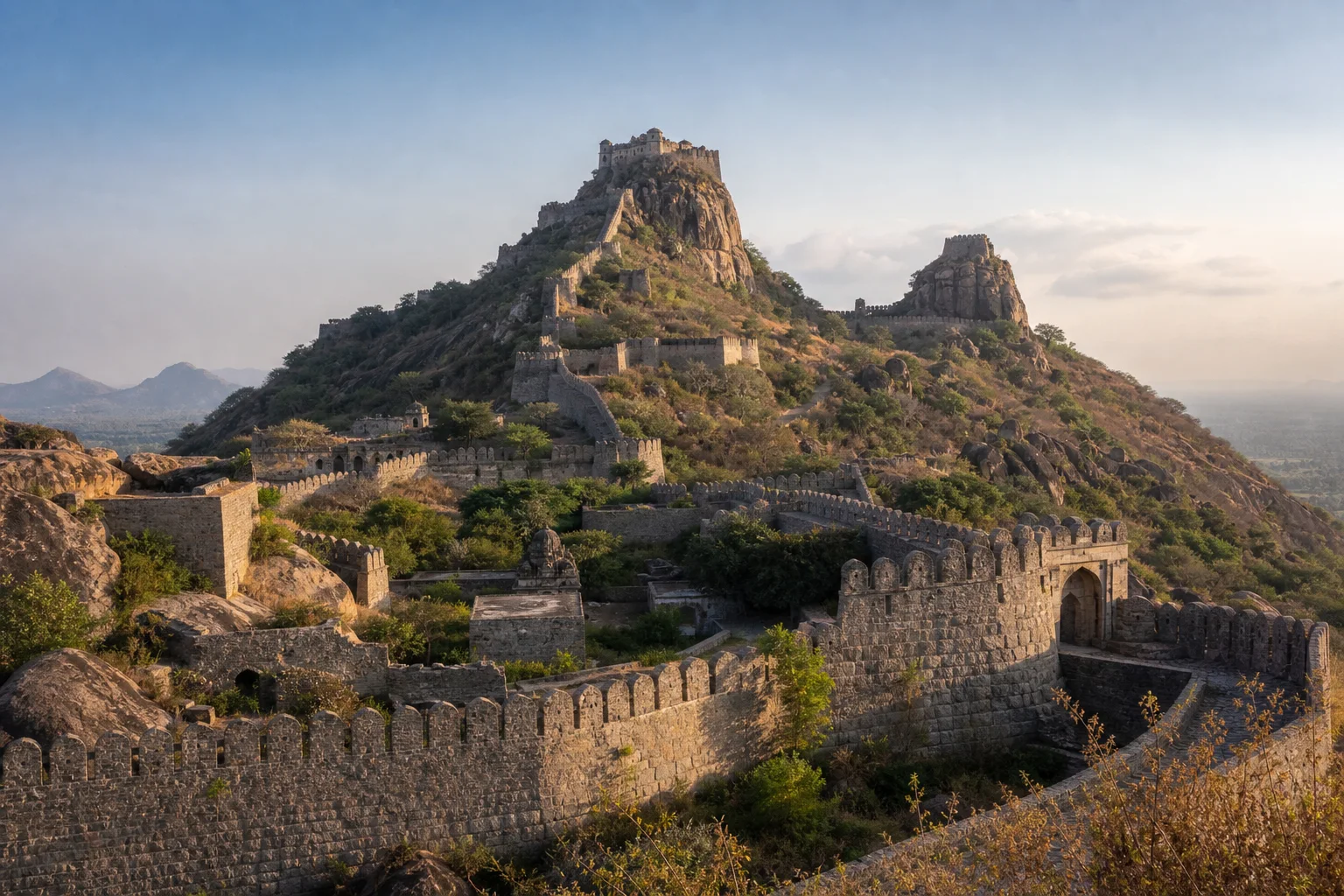
In July 2025, the World Heritage Committee inscribed the Maratha Military Landscapes of India on the UNESCO World Heritage List. Gingee Fort in Viluppuram district is one of the serial property's 12 components and the only component in Tamil Nadu. The other forts are in Maharashtra. That wording matters: Gingee was not inscribed as a stand-alone property, and the designation does not turn every fort, hill or old structure around the town into a UNESCO component.
The Committee inscribed the property under criteria (iv) and (vi), emphasizing a network of forts that adapted military planning to very different terrain. UNESCO's decision also identifies Gingee among the components protected by the Archaeological Survey of India. The inscription is therefore both recognition and a management responsibility. It invites a more careful reading of the fort while keeping property boundaries, buffer zones and conservation rules precise.
Sources for this section: UNESCO inscription decision, World Heritage documents.
A serial World Heritage property is one connected argument
A serial property brings separate places together because they collectively demonstrate a shared value. Gingee's significance in this inscription is not that it looks identical to the Sahyadri and coastal forts. Its value lies partly in difference: the system reached the Eastern Ghats and adapted to a granite hill landscape far from the principal Maharashtra clusters. The comparison is about military networks, terrain and historical operation, not a claim that all 12 components have one builder or one architectural form.
UNESCO's component maps distinguish the inscribed property from its buffer zone. Those maps should be used for formal boundary questions. A scenic viewpoint, nearby hill or secondary fortification may contribute to understanding the setting without automatically being inside the inscribed boundary. Responsible interpretation says component of the Maratha Military Landscapes of India, rather than shortening the designation to a misleading claim that all of Gingee town is a World Heritage Site.
Sources for this section: UNESCO inscription decision, Gingee component map.
Read the terrain before the buildings
Gingee's most legible feature is the relationship between steep granite hills and constructed defence. Fortification walls cross lower ground and climb toward elevated citadels. Gateways, bastions, paths and sight lines use topography to slow, channel and observe movement. The Viluppuram District Administration describes the major hill forts and the walls that connect them. Seen together, these are not isolated ruins but a defensive landscape organized across height and distance.
Water was equally important. Tanks, ponds and storage structures helped support occupation within a difficult rocky setting. A fort could not function through walls alone; people, animals, supplies, communication and water had to move through the system. Notice changes in level, the relationship between a gate and its approach, and the way a wall follows or interrupts the rock. These observations are more useful than treating every surviving structure as an interchangeable photo stop.
Sources for this section: Viluppuram places of interest, ASI Gingee monuments.
The UNESCO frame does not erase Gingee's layered history
The fort landscape existed and changed across multiple political phases. Local and official accounts connect Gingee with regional rulers, Vijayanagara-Nayaka authority, Maratha control, Mughal and Arcot power, French occupation and British control. Individual structures and repairs cannot all be assigned to one phase simply because the current World Heritage property focuses on the Maratha military system. A designation highlights a particular global argument; it does not replace the site's full chronology.
This is why architectural labels require care. A granary, audience structure, temple, mosque, wall or gateway may reflect different periods, uses and interventions. Popular stories about individual rulers also belong to regional memory and should be distinguished from inscriptions, architectural analysis or archival evidence. The best reading holds these layers together without forcing the whole fort into a single heroic narrative.
Sources for this section: Viluppuram places of interest, ASI Gingee monuments, World Heritage documents.
Recognition increases the need for precise conservation
UNESCO recognition does not mean a site has finished changing. Stonework weathers, vegetation affects masonry, paths erode and visitor pressure concentrates at gateways, steps and viewpoints. The World Heritage decision asks for continuing management, monitoring and protection across the serial property. At Gingee, this responsibility sits alongside ASI protection and the needs of a living town and landscape.
Visitors contribute through simple choices: stay on authorized paths, do not climb fragile walls, avoid scratching names into stone, carry waste out and accept barriers or closures. Drone use, commercial photography and access beyond public areas require current permission. A map pin or visible trail is not evidence of legal entry. Conservation is easier when visitors treat the fort as protected evidence rather than as an unrestricted adventure ground.
Sources for this section: UNESCO inscription decision, ASI Gingee monuments.
Plan for heat, height and current rules
Gingee's hills and exposed stone can make a visit physically demanding. Choose a realistic section, carry water, use sun protection and avoid building a schedule around an assumed climb time. Rain, heat, maintenance and local controls can change which paths are sensible or open. Official district or ASI information should be checked close to travel; historical articles cannot supply permanent opening hours, ticket prices or safety conditions.
A useful first visit can focus on one relationship: lower enclosure to hill citadel, gateway to approach, or water structure to defended settlement. Use the district guide for regional context and Maps for broad orientation, but let signs and staff determine movement on site. Gingee becomes more intelligible when the visitor asks how the landscape worked, what changed over time and which evidence still needs protection.
Sources for this section: Viluppuram places of interest, ASI Gingee monuments.
Sources & Further Reading
These authoritative references support the historical, geographic, or seasonal context in this story. Current conditions and operating details still require a fresh official check.
- Decision 47 COM 8B.16: Maratha Military Landscapes of India · UNESCO World Heritage Centre
- Maratha Military Landscapes of India - Documents · UNESCO World Heritage Centre
- Gingee Fort Property Boundary and Buffer Zone · UNESCO World Heritage Centre
- Gingee Fort and Places of Interest · Viluppuram District Administration
- List of Monuments and Sites - Gingee Sub-Circle · Archaeological Survey of India, Chennai Circle
Related Stories
A Heritage Weekend from Chennai: How to Choose a Meaningful Route
A practical way to shape a heritage weekend from Chennai around one good question, a measured pace, and a choice between city and nearby extensions.
Beyond the Cholas: Exploring Pallava Heritage Across Tamil Nadu
Follow Pallava heritage from Kanchipuram's sacred city to Mamallapuram's coastal stone workshop, learning to compare form, material and evidence.
How to Read a Tamil Nadu Temple: Gopurams, Mandapams, Prakarams and Sacred Space
An architectural reading guide to gateways, halls, enclosures, sanctuary towers, tanks, sculpture and inscriptions, grounded in the fact that temples remain living sacred places.
Frequently asked questions
Is Gingee Fort itself a UNESCO World Heritage Site?
Gingee Fort is one of 12 components of the serial World Heritage property named Maratha Military Landscapes of India.
Does the inscription cover every fort structure around Gingee?
No. Formal property and buffer boundaries are defined in UNESCO's component maps; nearby heritage does not automatically share the designation.
Are current opening hours included here?
No. Hours, tickets, path access and safety controls must be checked with ASI or the district authority close to travel.
Editorial attribution
Prepared and reviewed by My Tamil Nadu Editorial Desk. Modified 25 August 2026.